John1 Posted September 3, 2022 Share Posted September 3, 2022 Hey Chuck, Question for you - are you flying with "Live Weather" or are you manually loading in custom weather for each flight? I haven't been able to get Live Weather to work for a few months. ATIS tells me that it's pouring rain, outside the cockpit it, not a cloud in the sky. Quite frustrating, this used to be a feature that worked nicely until one of Asobo's "updates" broke it. Link to comment Share on other sites More sharing options...
ChuckD Posted September 3, 2022 Author Share Posted September 3, 2022 Hi, John. I'm using live weather and haven't really had much issue with it. To be fair, I've been flying in South America a lot, so I can't visually check the weather to confirm. However, what ATIS is telling me, and what METARs for the local areas say seem to line up reasonably well with what I'm seeing in the sim. About the only oddity is that sometimes, ATIS will say "visibility 3" and it turns out to be clear. I've had issues like you're describing, but they went away on their own. :/ Link to comment Share on other sites More sharing options...
ChuckD Posted September 10, 2022 Author Share Posted September 10, 2022 Full photo gallery: https://postimg.cc/gallery/D8030CP Total trip time: 30.9 hrs Route: Having dedicated ourselves to the idea of circumnavigating South America, our journey first took us west from Pedernales to Maracaibo and thence to Central America via the Panama Canal. Being a WWII enthusiast, I've always known what a role the Panama Canal played in getting shipping (both warships and logistical vessels) from the Atlantic to the Pacific. Therefore, I wanted to see the Panama Canal first hand. So, with that, we chose a route that would first get us out over the ocean to clear any major terrain, then turn southwest towards the northern end of the Panama Canal. From there, we'd drop down and run at tree-top level through the canal to finally land at Panama City. (Disclaimer: Don't do this in real life. Pretty sure you'll get shot down post haste.) Sadly, much of the stock terrain surrounding the canal area is a bit underwhelming. I believe there are additional payware add-ons that you can get to spruce the area up a bit, but I haven't bought them. So, the eye candy here is a bit weak. Weather: Moderate to heavy clouds throughout, storms in vicinity of destination. Flight Log: Departure from Maracaibo was by the book with no major issues. With mountains looming out of the clouds to our south, it was clear the route we'd chosen was the right one. We reached our cruising altitude of 12,500' and turned southwest. As we cruised along the northern coast of Columbia, the cloud deck started to thicken. We drew nearer to the northern end of the Canal entrance and began our decent. As we roared low over the docks at Cristobol, I couldn't resist opening the throttles. 72Z responded like a racehorse, surging forward with her R-985's screaming. Ripping past the Puente Atlantico bridge... ... we were soon passing over the Agua Clara locks. This dumped us into Gatun Lake, where we dodged around islands until we reached the beginning of the canal proper near Gamboa. As we raced south, dark storm clouds brewed in the distance. ATIS at Panama City airport was still calling for VFR weather, so we pushed on, passing low over the Miraflores locks at the southern end of the canal. To our left, Panama City beckoned out of the deepening gloom. Tower gave us instructions to enter right traffic for runway 01, which was a bit odd given that Ancon Hill sits pretty much squarely in that path. A left traffic call would have been better, but whatever. We crossed over the runway at midfield, banked right and entered the traffic pattern. Skimming between two hills, our final approach and touchdown were smooth. Just as we taxied to parking and shutdown, the skies above us began rumbling and soon were pouring rain. But, by then, we were safely on the ground. John1 and Landrotten Highlander 2 Link to comment Share on other sites More sharing options...
ChuckD Posted September 10, 2022 Author Share Posted September 10, 2022 Update 2 for today: Full photo gallery: https://postimg.cc/gallery/D8030CP Total trip time: 35.6 hrs Route: Today's route would take us south along the western coast of Columbia to Quito, Ecuador. For the most part, our flight would keep us over the relatively narrow coastal plain that lies between the shores of the Pacific and the foothills of the Andes mountain range. As a final jog into Quito, we would turn east, to follow the PALAD STAR1E terminal arrival. This is a standard arrival procedure used for this airport to prevent airplanes from doing things like smacking mountains in bad weather. Turns out, this was a good idea as there were plenty of clouds in the vicinity of our destination. Quito's Mariscal Sucre airport, one of the busiest in South America, sits at an elevation of 8,700 feet and is nestled in a plateau among many mountains that, hilariously, often exceed the service ceiling of the Beech 18. So, in short, if I'm not careful in these mountains, we could quickly end up like a *lot* of other pilots over the years who've gotten themselves into irrecoverable danger and ended up a statistic. Weather: Moderate to heavy clouds throughout, storms in vicinity of destination. Flight Log: All through the night, thunderstorms rumbled through the Panama City area, finally tapering off in the wee hours of the morning. A gorgeous dawn was breaking as we climbed aboard and prepared for departure. Zulu's R-985s roared to life and soon we were off into the sunrise. We climbed into the rising sun and settled into our cruising altitude of 14,000'. Below, a blanket of puffy white clouds drifted slowly by. As the Andes mountain range came into view, it occurred to me that we would soon be navigating between those craggy peaks. We passed over Buenaventura, Columbia and continued south. After several hours, I began prepping for the terminal arrival. Our destination lay beyond those hills. Intercepting the VOR radial, we began picking our way through the mountains. Clouds loomed in every direction above us... as did mountain peaks. We popped in and out of clouds, as we made the turn on to the final approach course. Finally, Mariscal Sucre became distinguishable in the haze. Lining up on final approach, the runway beckoned. A commercial airliner was waiting for us... ... and it blasted off moments after we cleared the runway. We taxied and shutdown just as a cloudbank rolled in and it began to rain. That didn't bode well, because the plan was to depart again soon after a quick turnaround. I privately wondered if my instrument skills would be up to the challenge, or if we would end up scattered across a hillside somewhere in Ecuador. Jan_G, John1 and Landrotten Highlander 3 Link to comment Share on other sites More sharing options...
ChuckD Posted September 11, 2022 Author Share Posted September 11, 2022 (edited) Full photo gallery: https://postimg.cc/gallery/Rws9kMs Total trip time: 40.9 hrs Route: The second flight of the day will take us first west to clear the mountains, then south along the coast to Lima, Peru. Given the hard IMC weather, and the proximity of massive mountain peaks, we'll be following the TEMOX 2A RNAV (GPS) departure. This involves a climb to 9000, then a turn to a GPS point which must be crossed at or above 11,500, then another turn to the ILPEX waypoint (12,600' minimum), then a turn southwest to the TEMOX point, whose minimum safe altitude is 17,000ft. Once clear of TEMOX, we'll be out over the coastal plain again, which we'll follow to Lima. Weather: Rain and low clouds at both departure and destination, scattered clouds en route. Flight Log: Sure enough, as the line crew topped off Zulu's tanks, the clouds continued to pour rain down upon us and visibility dropped significantly. I made a mental note to sump the tanks diligently to ensure no rain water had made its way into the tanks during the fueling operation. This departure would be something of a challenge. While the theoretical service ceiling of the Beech 18 is around 26,000ft, I'd never really taken her above 15,000. So, clearing the TEMOX departure waypoint at 17k would set a new record for us and would be the first leg to require supplemental oxygen. For all her amenities, Zulu is not pressurized and the air at 17k is thin enough to cause hypoxia. As we climbed aboard, rain pattered on Zulu's aluminum skin. Lining up on the runway, we thundered into the clouds. We popped intermittently into clearings; just long enough to see mountain peaks towering overhead. We passed the first two waypoints of the published departure, Zulu climbing beautifully into the leaden clouds. Clearing the ILPEX waypoint, we burst clear of the clouds and banked southwest. Once past TEMOX, we dropped to 15,000ft and settled into cruise. The beauty of the Ecuadorian and Peruvian coastal mountains was jaw dropping. As we neared Lima, the clouds began to thicken and the airport was socked in with strong coastal winds from the south. For this, we'd shoot the ILS (instrument landing system) approach into runway 15. Tuning NAV radio 1 to 109.7 and turning on its audio feed, I heard the familiar chirp of the morse code identifier. I repeated the process for NAV2 to dial in the LIM VOR in case I had to execute the missed approach procedure. We dropped to 2000' in worsening weather. At 5.9 miles on the DME (distance measuring equipment), we were at the final approach fix and had intercepted the glideslope to begin our decent. Somewhat rusty, I found myself "chasing the needle" or making too many and too severe course corrections to stay on the localizer path. I'll have to practice that a bit to clean up my approaches. After a few moments, the runway loomed out of the gloom. After 10 hours in the air, we were all exhausted and ready to turn in for the night. I was happy that the instrument portions of the flight went so smoothly, as I had been concerned. But, it was evident that I was rusty, so I'd have to practice procedures a bit before I was truly comfortable in IMC again. Ah well, tomorrow is another day and will see us off to Tacna, Peru. Edited September 11, 2022 by ChuckD Landrotten Highlander, Jan_G and John1 3 Link to comment Share on other sites More sharing options...
Dpgsbody55 Posted September 13, 2022 Share Posted September 13, 2022 On 9/3/2022 at 7:21 PM, ChuckD said: You're right in that the terrain data is a little out of whack, but I think the game makes up for it by having a big plot of trees at the crest of the hill. That's another issue with this sim. What idiot scenery designer put 50ft trees right before the touch down point?? Anyway, glad you're having fun with the Twin Beech. I don't have that one right now. I still miss Milton Shupe's Twin Beech's as they were heaps better than any payware offerings at that time. Might give this one a try, if I can stop spending money on all the new LSP releases right now...... Cheers, Michael Link to comment Share on other sites More sharing options...
ChuckD Posted September 13, 2022 Author Share Posted September 13, 2022 11 hours ago, Dpgsbody55 said: That's another issue with this sim. What idiot scenery designer put 50ft trees right before the touch down point?? Anyway, glad you're having fun with the Twin Beech. I don't have that one right now. I still miss Milton Shupe's Twin Beech's as they were heaps better than any payware offerings at that time. Might give this one a try, if I can stop spending money on all the new LSP releases right now...... Cheers, Michael I think it's more the AI foliage generation algorithm that plops trees 20' short of the touchdown zone than anything. Of course, I also think St Bart's was/is a hand-crafted airport, so... Who knows. The Beech in FS2020 is very good, but not superb. There are still some bugs present, and performance can get weird in certain flight envelopes. My biggest gripe is aimed at FS2020's taildragger physics. They are just wrong and it's an ongoing complaint since release. All taildraggers are super squirrelly on the ground. Link to comment Share on other sites More sharing options...
John1 Posted September 14, 2022 Share Posted September 14, 2022 21 hours ago, Dpgsbody55 said: That's another issue with this sim. What idiot scenery designer put 50ft trees right before the touch down point?? Anyway, glad you're having fun with the Twin Beech. I don't have that one right now. I still miss Milton Shupe's Twin Beech's as they were heaps better than any payware offerings at that time. Might give this one a try, if I can stop spending money on all the new LSP releases right now...... Cheers, Michael There is a fix out there. Go on Youtube and search for MSFS Tree Fix or something similar. Takes a few edits to a particular file but nothing too involved. Took me all of 5 minutes. Just make a copy of the file before you start tinkering "just in case". Link to comment Share on other sites More sharing options...
ChuckD Posted September 14, 2022 Author Share Posted September 14, 2022 11 hours ago, John1 said: There is a fix out there. Go on Youtube and search for MSFS Tree Fix or something similar. Takes a few edits to a particular file but nothing too involved. Took me all of 5 minutes. Just make a copy of the file before you start tinkering "just in case". Good to know. Thanks for the heads-up. I'll check it out. Link to comment Share on other sites More sharing options...
John1 Posted October 12, 2022 Share Posted October 12, 2022 So how's that flight going? You haven't gone "Emilia" on us have you? Should we scramble our virtual SAR forces? Landrotten Highlander 1 Link to comment Share on other sites More sharing options...
Dpgsbody55 Posted October 14, 2022 Share Posted October 14, 2022 I was wondering the same thing. Has sim update 10 stuffed up ChuckD's fun, just as it has mine?? I can't get my sim to work since this update. Cheers, Michael Landrotten Highlander 1 Link to comment Share on other sites More sharing options...
ChuckD Posted October 18, 2022 Author Share Posted October 18, 2022 Ha, no, I'm not lost on an island somewhere. The flights are still going. I'm just a lot better about making the flights than I am making the posts. I'm part way through my tour of Africa right now. Just need to get off my duff and post. Landrotten Highlander, John1 and Dpgsbody55 1 2 Link to comment Share on other sites More sharing options...
ChuckD Posted October 22, 2022 Author Share Posted October 22, 2022 Hello, all. I'm back with a long overdue update. As can probably be expected, I've been busy with things like work, family, studying, other hobbies, etc. The good news is that I've been continuing my round the world flights. The less good news is that I've not been super diligent about posting. That said, I think I'm going to try a somewhat different approach (get it?) from here on out. I'd like to start posting closer to, if not immediately after, the flight that I just finish. It's fresher in my brain and I can type out a few notes while the flight is actually proceeding. To that end, I'm going to post a synopsis of the legs I've completed so far, along with interesting highlights. Let's face it, "we took off, cruised, and landed" gets boring and repetitive, so unless there's something particularly interesting, I'm going to reduce the narrative and stick to the screenshots. I have updated (and will continue to update) the OP with links to the full screenshot galleries for all legs, so if you want to explore a particular leg, you can go there and check out the whatever you'd like. A couple fun notes since my last major update. 1. I discovered that the aircraft I'm simulating, and that currently sits abandoned at my local airport, was, in fact, a warbird. I'd always thought it was built in 1952, but it turns out it was actually *rebuilt* by the manufacturer in 1952 to fulfill an Air Force contract for transport aircraft. She began life as an AT-11 trainer aircraft in 1943 and was used to train air crews for the war effort. 2. I got a new video card. The difference in performance and visual quality is amazing, though I'm still pretty impressed with how my old 1070ti held up all these years. On the plus side, the 3080 puts out enough heat that I was able to decommission the small space heater I have in my office. 3. I bit the bullet and taught myself how to do a custom skin for 72Z, so it now looks closer in the game to what it does in real life. 4. I also bit the bullet and bought the Honeycomb Alpha and Bravo yoke and throttle quadrant to replace my aging Thrustmaster Warthog HOTAS. The yoke and throttle are awesome (and huge) and are much closer to real life for civilian aviation. Flying the Beech 18 with a fighter stick felt... off. Photo dump coming shortly. Landrotten Highlander 1 Link to comment Share on other sites More sharing options...
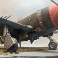
ChuckD Posted October 22, 2022 Author Share Posted October 22, 2022 When last we left our intrepid little warbird that could, we were in Tacna, Peru, preparing for a flight to visit the famous salt flats of Bolivia. Since then, we've made our way south around the tip of South America, to the Falkland Islands, back up the eastern coast of South America, across the Atlantic, and through parts of north central Africa, a distance of around 20,000 miles. As of this writing, we are on leg 41 of our journey, winging our way over the countries of Togo and Benin en route to Nigeria. This update itself will get us up to the mid-Atlantic crossing. Africa will be a subsequent update. For the most part, the flights have been pretty routine. Weather has been decent, aircraft ground performance remains squirrely (though better after an update in mid-September), and flights pretty predictable. Leaving Tacna, we headed to Uyuni, near the Bolivian salt flats. I couldn't resist landing there. It was tougher than I expected for two reasons. First, over a featureless white terrain, there is *zero* depth perception and, second, the game doesn't model the flats as (ahem) flat as they're reported to be. So, yeah... that was a bouncy landing. From Uyuni, we crossed back over the Andes and headed south along the coast to La Serena. The desolation of this area was profound. La Serena's airport is tucked into a mountain valley. Thou shan't go missed approach lest ye scatter thine airplane 'cross yonder mountain. The runway is just under the left vertical stabilizer in this shot. From La Serena, we continued south to Santiago, Chile. The southern spurs of the Andes were our constant companions as we trekked down the coast of the South American continent. Due to a low-lying haze and sharply mountainous terrain nearby, we flew the ILS 35 instrument approach into Santiago. We left Santiago later that day in what would turn out to be the first real hair-raising leg of the journey. We departed out of the same haze as we'd arrived in, using a standard instrument departure to safely clear the mountains. As we cruised, the sun began to set and the clouds thickened below us. As the sun dipped below the horizon, rain began speckling our windscreen and pelting Zulu's aluminum skin. Darkness quickly fell and the rain, though scattered, intensified. We groped through the darkness on the VOR approach into our destination, but as the GPS ticked down the distance, no runway lights were visible. It quickly became clear that this airport did not have runway lights, so with the wind buffeting us, the rain pelting the aircraft, and our fuel down to about 90 minutes of flight time remaining, we turned for our alternate of Puerto Montt. I was only reasonably sure this airport would have runway lighting, but as we lined up on the VOR approach, the runway lights slowly blossomed from the dark and haze. We touched down safely and spent the evening in Puerto Montt. Early the next morning, we departed again on another long leg, this time to Punta Arena in Argentina. Takeoff into the sunrise was beautiful. The visuals in this game are just astounding sometimes. The sky turned from black to purple... ...purple to pink... ...pink to gold... ...gold to vibrant blue... The snow-capped mountains of southern South America welcomed us with buffeting and strong winds. On the far side, we descended back into greenery and landed at Punta Arena. From there, we hopped a short flight south to Port Williams, the southern-most airport on the continent (at least large enough to accommodate a Beech 18). Our next stop was Mount Pleasant on the Falkland Islands. We cleared the continent and went 'feet wet' over the south Atlantic. We arrived in Mount Pleasant at dusk with high winds buffeting the aircraft. After a couple day stay, we departed in the evening for a night flight back to the continent at Puerto Deseado. It was here that I finally repainted Zulu to match her real-life livery. I added my own flair to give her some pizzazz as a nod to my favorite gal in the world. And thus, Sweetpea II was born. We worked our way north along the coast towards Montevideo. The contrast of flat terrain to the mountains we'd become so accustomed to was stark. Being the history enthusiast I am, I had to fly over the first of the WWII landmarks on this journey. Here, at the mouth of the River Plate, the German pocket battleship Graf Spee (https://en.wikipedia.org/wiki/German_cruiser_Admiral_Graf_Spee) was scuttled after heavy damage from British cruisers. See the Battle of the River Plate: https://en.wikipedia.org/wiki/Battle_of_the_River_Plate The remains of her wreck lie below the water here, just south of Montevideo proper: The landing at Montevideo was uneventful and we soon loaded back up to head to Asuncion. Dusk settled as we slipped into Asuncion to rest for the night. I'd been looking forward to the next leg to Rio de Janeiro for quite a while as I'd really wanted to see Christ the Redeemer. After clearing the inland plains, the bustling metropolis of Rio slowly slid into sight. I spotted our destination... ... but first had to pay my respects on this pilgrimage. We landed without incident in a small business airport. The next morning, the weather had socked us in. We filed IFR and planned for an instrument departure as high mountains were all around. This would be the first flight with my new graphics card and I was not disappointed. Fortunately, the instrument climbout was straight forward and we were soon cruising over a blanket of clouds. As we neared our destination of Natal, they cleared somewhat, leaving a thin, low haze. After shooting the ILS approach, we arrived without trouble. This was exciting, because Natal would be the last place Sweetpea's tires would touch South American continental soil. Our next leg would take us to a brief refueling stop at San Fernando de Noro. From there, we would stretch our legs to get to Ascension Island in the middle of the Atlantic. Takeoff... ... and feet wet. Bye bye, South America. We really are small specks in the cosmic universe. Despite high winds, the landing at San Fernando was decent. After playing chicken with a ground vehicle... ... and taking on a full load of fuel, we were off across the Atlantic to Ascension Island. For this long leg, I simulated auxiliary fuel tanks by adding weight to the fore and aft baggage compartments (600lbs and 300lbs respectively). After doing some weight and fuel burn calculations, I figured this gave us an endurance of around 11 hours which was more than enough to comfortably see us to Ascension Island. Now, in real life, I'm not sure I could actually land at Ascension as it's an RAF military base. But, hey, it's a game. Takeoff this time was a little hairy. I'd forgotten to set the trim to takeoff and the aircraft steadfastly refused to leave the runway. I realized my mistake (use a checklist, people) in time and jockeyed the trim to get her nose up and off the runway. The skies were clear and calm (thankfully) as we cruised into the evening hours. Well after dark, we picked up Ascension Island visually and began our approach. We touched down and taxied to a stop. (that's the airport's rotating beacon shining above us) Our South American adventure was finally at a close. Next, we're on to the wild world of Africa! Landrotten Highlander 1 Link to comment Share on other sites More sharing options...
John1 Posted October 22, 2022 Share Posted October 22, 2022 Awesome update, thanks for taking what is surely a considerable amount of time to pull this together. Hope you enjoy the new video card. Link to comment Share on other sites More sharing options...
Recommended Posts
Create an account or sign in to comment
You need to be a member in order to leave a comment
Create an account
Sign up for a new account in our community. It's easy!
Register a new accountSign in
Already have an account? Sign in here.
Sign In Now